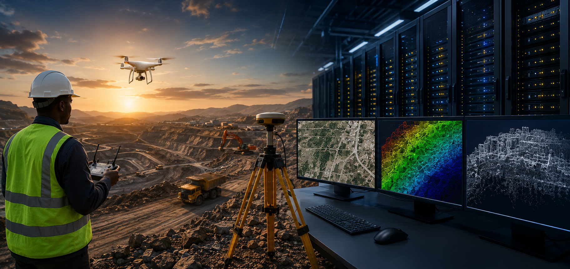
Across Africa, drone surveying and LiDAR adoption are accelerating rapidly. Mining operations, infrastructure corridors, renewable energy projects, and land development initiatives are generating increasingly large geospatial datasets every day.
While aerial acquisition capabilities have advanced significantly, processing infrastructure remains a major bottleneck.
High-resolution orthomosaics, dense LiDAR point clouds, Digital Elevation Models (DEMs), and 3D terrain reconstructions require enormous computational power. For many survey firms, processing these datasets locally introduces operational challenges such as:
- Long turnaround times
- Limited GPU availability
- High infrastructure investment costs
- Processing delays between field operations and delivery
- Underutilized hardware outside active workloads
As project scale increases, traditional workstation-based workflows become increasingly inefficient.
A Shift Toward Continuous Processing Infrastructure
To overcome these limitations, several African geospatial operators are now utilizing Agniforge’s high-performance GPU infrastructure for continuous overnight processing workflows.
Powered by a multi-GPU NVIDIA A100 architecture, Agniforge’s processing environment enables large drone and LiDAR datasets to move directly from field acquisition into accelerated computation pipelines—without waiting for local office hours or manual scheduling windows.
This transforms traditional workflows from:
Collect → Wait → Process → Deliver
into:
Collect → Process Continuously → Deliver
The result is significantly faster operational turnaround across large-scale geospatial projects.
Why Overnight Processing Matters
In many large survey operations, data collection is completed during daylight hours while computation only begins later—often creating idle delays before actual processing starts.
Agniforge’s infrastructure model eliminates this gap.
As field teams across African regions complete UAV or LiDAR acquisition missions, datasets can immediately enter processing pipelines within Agniforge’s GPU environment. By leveraging timezone differences and continuously active compute infrastructure, processing operations continue overnight, enabling outputs to be ready by the next operational cycle.
This approach provides major advantages:
- Faster project turnaround
- Reduced operational downtime
- Continuous compute utilization
- Accelerated engineering decision-making
- Improved scalability for simultaneous projects
Supporting Large-Scale Geospatial Workflows
Modern infrastructure and mining projects often generate hundreds of gigabytes of raw data from a single deployment cycle.
Agniforge’s GPU infrastructure is optimized to support workloads such as:
- UAV photogrammetry processing
- LiDAR point cloud reconstruction
- Orthomosaic generation
- DEM and DSM creation
- Corridor terrain modeling
- Volumetric analysis
- High-resolution mesh generation
- AI-assisted visual inspection workflows
The infrastructure combines:
- Multi-GPU NVIDIA A100 compute architecture
- High-memory processing environments
- High-speed NVMe storage systems
- Optimized geospatial processing pipelines
- Surface AI integration workflows
This enables enterprise-grade processing performance for complex and data-intensive operations.
Enabling Operational Efficiency Without Infrastructure Ownership
Building and maintaining enterprise GPU infrastructure can be prohibitively expensive for many organizations.
High-performance compute environments require:
- GPU hardware investment
- Cooling and power management
- High-speed storage architecture
- Infrastructure maintenance
- Continuous software optimization
Additionally, local processing hardware often remains idle outside active project windows.
By externalizing heavy computation into Agniforge’s continuously active infrastructure environment, organizations can:
- Reduce capital expenditure
- Eliminate infrastructure maintenance overhead
- Scale processing capacity on demand
- Maintain operational flexibility
- Access enterprise-grade compute without ownership complexity
This creates a more efficient and scalable operating model for rapidly growing geospatial firms.
Accelerating Mining, Infrastructure, and Corridor Projects
The demand for high-speed processing is particularly critical in sectors such as:
Mining
Large terrain models, stockpile calculations, and safety mapping operations require rapid turnaround for operational planning.
Infrastructure & Highways
Road corridor surveys, alignment planning, and topographic intelligence depend on continuous processing efficiency.
Utilities & Transmission
Powerline inspections and corridor intelligence generate substantial visual and LiDAR datasets requiring accelerated analysis.
Renewable Energy
Solar and wind infrastructure inspections increasingly rely on thermal and AI-assisted processing pipelines.
Through overnight GPU processing workflows, organizations can significantly shorten the delay between field acquisition and actionable engineering outputs.
Building a Globally Distributed Geospatial Processing Ecosystem
As geospatial datasets continue growing in scale and complexity, competitive advantage will increasingly depend not only on data acquisition—but on processing efficiency.
Agniforge’s infrastructure model represents a shift toward globally distributed, continuously active geospatial computation systems capable of supporting international survey operations at scale.
By integrating high-performance GPU infrastructure with optimized processing pipelines and globally aligned execution cycles, Agniforge enables geospatial organizations to operate faster, more efficiently, and with greater scalability across complex projects.
The future of geospatial intelligence will not be defined solely by who captures the data fastest.
It will be defined by who can process, analyze, and deliver it at global operational speed.