The mining industry in India is undergoing a major transformation driven by technology, efficiency, and regulatory compliance. As the demand for minerals, coal, and natural resources continues to grow, mining companies are under constant pressure to improve productivity while ensuring safety and environmental responsibility. In this evolving landscape, drone survey and UAV mapping have emerged as powerful tools that are redefining how mining operations are planned, monitored, and managed.
Traditional mining surveys have always been time-consuming and labor-intensive. Survey teams often have to work in hazardous environments, climb unstable surfaces, and manually collect data over large areas. This not only increases operational risk but also delays decision-making. Drone-based surveying eliminates these challenges by enabling fast, accurate, and safe data collection from the air.
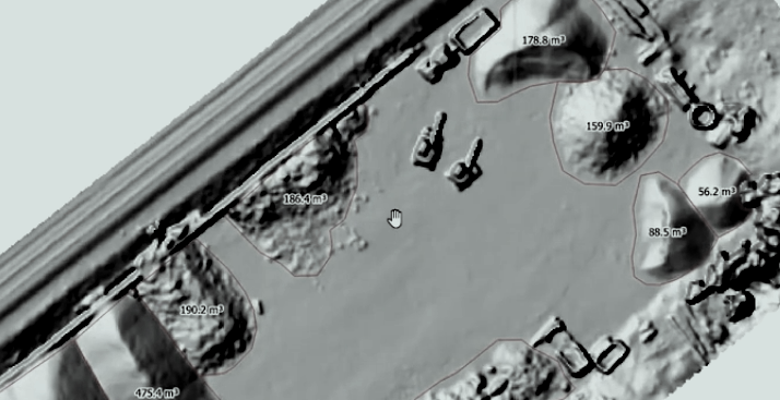
UAV mapping in mining involves the use of drones equipped with high-resolution cameras, LiDAR sensors, and GPS-based positioning systems. These drones capture aerial images and terrain data, which are processed into orthomosaic maps, digital elevation models, and 3D mine models. The level of accuracy achieved through drone surveys is extremely high, often reaching centimeter-level precision, making it ideal for critical mining applications.
One of the most important uses of drone surveys in mining is volume calculation. Accurate measurement of stockpiles, excavation areas, and overburden is essential for operational planning and financial reporting. Traditional methods often lead to estimation errors, but drone mapping provides precise volumetric data within a very short time. This helps mining companies optimize resource utilization, reduce losses, and maintain transparency in reporting.
Mine planning and design have also been significantly improved through UAV mapping. By generating detailed 3D models of the mine, engineers can analyze terrain, plan excavation strategies, and optimize haul routes. This leads to better decision-making and improved operational efficiency. Additionally, drones can be used to monitor changes in the mine over time, providing valuable insights into progress and performance.
Safety is another critical area where drone surveys are making a major impact. Mining environments are inherently dangerous, with risks such as landslides, unstable slopes, and gas exposure. Drones eliminate the need for surveyors to physically enter these hazardous zones. Instead, data can be collected remotely, ensuring the safety of personnel while maintaining high-quality output.
Environmental monitoring and compliance have become increasingly important in the mining sector. Government regulations require companies to track land use, monitor environmental impact, and ensure proper rehabilitation of mined areas. UAV mapping enables continuous monitoring of these parameters, helping companies stay compliant with regulations. Drones can capture detailed data on vegetation, water bodies, and land degradation, making environmental reporting more accurate and efficient.
Another key advantage of drone surveys in mining is speed. Large mining areas that would normally take several days or even weeks to survey can now be covered in a few hours. This allows for more frequent data collection and real-time monitoring of operations. Faster data availability means quicker decision-making, which directly impacts productivity and profitability.
The integration of advanced technologies such as photogrammetry and LiDAR has further enhanced the capabilities of UAV mapping in mining. Photogrammetry allows the creation of detailed 2D and 3D models from aerial images, while LiDAR provides accurate terrain data even in areas with dense vegetation or complex topography. These technologies, combined with AI-based analytics, enable automated feature detection and predictive insights.
Cost efficiency is another major factor driving the adoption of drone surveys in mining. Traditional surveying methods require large teams, heavy equipment, and extended timelines, all of which increase costs. UAV mapping reduces manpower requirements and speeds up the entire process, resulting in significant cost savings. At the same time, it improves accuracy, reducing the need for rework and minimizing financial discrepancies.
In India, the adoption of drone technology in mining is growing rapidly due to supportive government policies and increasing awareness among industry players. Mining companies are recognizing the value of real-time data and digital transformation, leading to higher demand for UAV survey services. As competition increases, companies that adopt drone technology are gaining a clear advantage in terms of efficiency, safety, and compliance.
Looking toward the future, the role of drones in mining is expected to expand even further. Autonomous drone systems, real-time data processing, and digital twin technology will enable continuous monitoring of mining operations. Predictive analytics will help identify potential risks and optimize resource extraction, making mining smarter and more sustainable.
Drone survey and UAV mapping are revolutionizing the mining industry in India. They provide a faster, safer, and more accurate alternative to traditional surveying methods, enabling mining companies to improve productivity, reduce costs, and ensure compliance. As the industry continues to evolve, UAV technology will play a central role in shaping the future of mining operations.