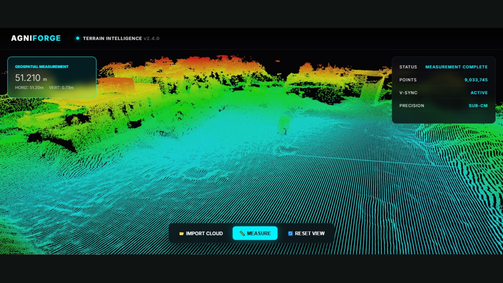
3D Laser Scanning

Unlocking the
Digital Terrain.

Experience extreme precision with Agniforge’s UAV LiDAR solutions. We penetrate dense vegetation and capture high-fidelity 3D environments with military-grade accuracy.

Agniforge LiDAR
The Technology

State-of-the-Art
Laser Acquisition

At Agniforge, we are pioneers in transforming how geospatial data is captured. Our advanced LiDAR systems scan the environment at millions of points per second, creating an exact digital replica of the world.

Combined with our team of expert surveyors, we deliver survey-grade results that meet the highest international standards for construction, mining, and urban engineering.

Laser Return Protocol Up to 5 Target Returns
Scanning Frequency 2,000,000+ Points/Sec
Relative Accuracy ± 2.5cm RMS
IMU Precision High-Order Tactical Grade
Intelligent Outputs

LiDAR Deliverables

3D Point Cloud Data

Ultra-detailed raw and denoised point clouds with intensity and RGB values.

DEM / DTM / DSM

Precision bare-earth terrain models filtered through dense vegetation.

Contour Maps

High-resolution topographic lines for engineering-grade land analysis.

Orthomosaic Imagery

Radiometrically corrected visual data for enhanced site visualization.

CAD & GIS Integration

Seamlessly export into DWG, DXF, or SHP formats for your design workflow.

Volumetric Analysis

Highly accurate stockpile calculations and earthwork cut/fill estimates.

Measurement Reports

Comprehensive analytical data for structural clearances and slope planning.

Technical Insight Report

In-depth interpretation of survey findings for stakeholder decision-making.

LiDAR Classification
Deep Classification

Smart Data
Categorization.

Our LiDAR expertise goes beyond just scanning. We offer advanced data classification that separates ground, high-vegetation, buildings, and powerlines into individual intelligence layers.

This allows engineers to see the true bare-earth topography even in thick forests, a capability that traditional photogrammetry cannot provide.

Project Intake

Initiate LiDAR Sequence