Minesite Survey & Mapping by Agniforge
Utilizing advanced drones with LiDAR, thermal imaging, and high-resolution cameras, we deliver precise and comprehensive surveys for mining operations worldwide.
Download Profile
Utilizing advanced drones with LiDAR, thermal imaging, and high-resolution cameras, we deliver precise and comprehensive surveys for mining operations worldwide.
Download ProfileAt Agniforge, our drone-based minesite surveys leverage state-of-the-art UAVs equipped with LiDAR, thermal imaging, high-resolution cameras, and video geotagging capabilities to provide precise and efficient data collection. This technology enables detailed mapping and analysis of minesites, supporting operational efficiency, safety, and resource management.
Our expert team processes aerial data, geotagged videos, and LiDAR point clouds to perform volumetric analysis, monitor stockpiles, and map terrain, delivering actionable insights for mining companies and site managers. Services like thermal inspections for equipment monitoring and orthomosaic mapping enhance safety and productivity across challenging mining environments.
With a commitment to innovation and adherence to global mining standards, Agniforge’s drone surveys offer survey-grade results for minesite management. Partner with us to optimize your mining operations and ensure sustainable resource extraction.
Our drone-based minesite survey services leverage advanced UAV technology for precise mapping, monitoring, and analysis to enhance mining operations.
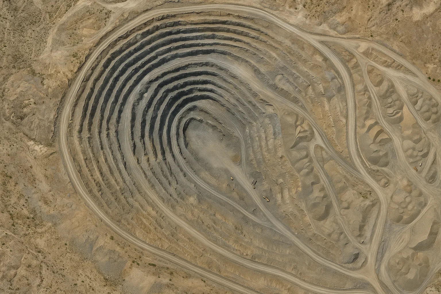
High-precision 3D mapping of minesite terrain using LiDAR, enabling accurate topographic models for planning and safety assessments.
Detect overheating equipment or electrical faults using thermal imaging, ensuring operational safety and maintenance efficiency.
Create detailed orthomosaic maps from high-resolution imagery, supporting site layout planning and environmental monitoring.
Capture geotagged video footage of minesites, enabling location-based analysis for operational oversight and documentation.
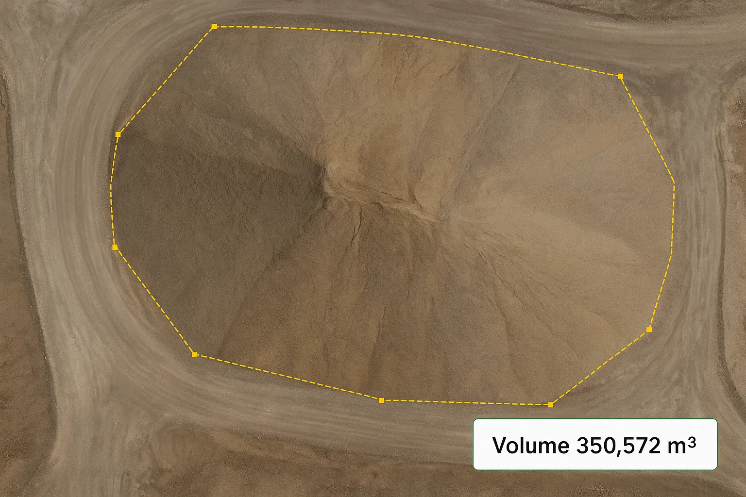
Agniforge’s drone-based volumetric analysis provides precise measurements of stockpile volumes, overburden, and extracted materials at minesites. Using advanced LiDAR and high-resolution imagery, our UAVs capture detailed 3D point clouds and orthomosaic maps to calculate volumes with survey-grade accuracy.
Our expert team processes this data to deliver comprehensive reports, enabling mining companies to optimize inventory management, track production rates, and plan resource extraction efficiently. Volumetric analysis reduces manual surveying efforts, enhances safety by minimizing personnel exposure to hazardous areas, and supports cost-effective operations.
Whether assessing stockpile quantities or monitoring site changes over time, Agniforge’s volumetric analysis ensures reliable data for informed decision-making in mining operations.
Our drone-based minesite surveys address critical needs in mining operations, safety, and resource management worldwide.
Accurately measure stockpile volumes using volumetric analysis to optimize inventory and production planning.
Monitor hazardous areas with thermal and LiDAR surveys to identify risks and ensure worker safety.
Use topographic and orthomosaic maps for efficient mine layout planning and infrastructure development.
Assess environmental impacts of mining activities using aerial surveys to ensure regulatory compliance.
Monitor site changes over time with geotagged videos and orthomosaic maps to track mining progress.
Leverage volumetric and terrain data to estimate resource quantities for operational and financial planning.