
Solar Inspection & Survey by Agniforg
Utilizing advanced drones with thermal imaging, LiDAR, and video geotagging, we deliver precise and comprehensive solar farm inspections worldwide.
Download Profile
Utilizing advanced drones with thermal imaging, LiDAR, and video geotagging, we deliver precise and comprehensive solar farm inspections worldwide.
Download ProfileAt Agniforge, our drone-based solar farm surveys leverage cutting-edge UAVs equipped with thermal imaging, LiDAR, high-resolution cameras, and video geotagging capabilities to provide precise and efficient inspections. This technology enables rapid data collection across large-scale solar installations, even in remote or challenging terrains.
Our expert team processes aerial data, geotagged videos, and LiDAR point clouds to assess photovoltaic (PV) panels, detect defects, monitor vegetation, and map sites, delivering actionable insights for maintenance, optimization, and planning. Services like thermal inspections and dust detection ensure peak performance and longevity of solar assets.
With a commitment to innovation and adherence to global solar industry standards, Agniforge’s drone surveys offer survey-grade results for solar farm management. Partner with us to maximize the efficiency and reliability of your solar infrastructure.
Our drone-based solar survey services leverage advanced UAV technology for comprehensive inspections, defect detection, and site planning.
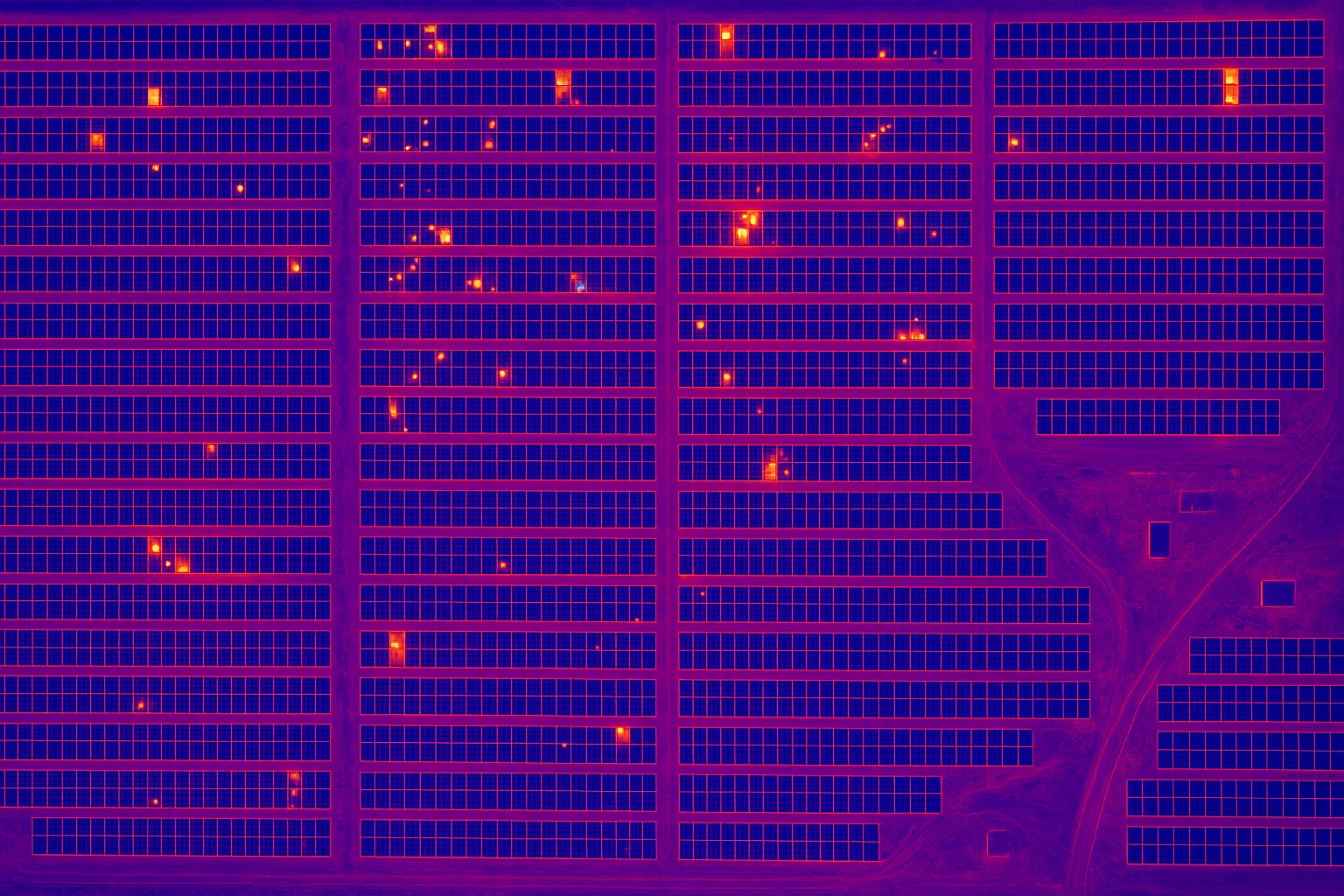
Identify hotspots, defective cells, and electrical faults in PV panels using thermal imaging for proactive maintenance.
Precise 3D mapping and analysis of solar farm topography, optimizing layout and detecting structural anomalies.
Capture geotagged video footage of solar farms, enabling location-based analysis for inspections and documentation.
High-resolution aerial inspections to detect cracks, soiling, or degradation in photovoltaic panels for optimal performance.
Our drone-based solar surveys address critical needs in solar farm maintenance, optimization, and planning worldwide.
Create location-referenced video records for solar farms, supporting inspections, compliance, and project monitoring.
Detect defects in PV panels and electrical systems for timely repairs, maximizing energy output and asset lifespan.
Accurate LiDAR and aerial data for designing and optimizing solar farm layouts, minimizing environmental impact.
Identify soiling or debris on PV panels using high-resolution imagery, ensuring optimal energy efficiency.
Monitor and manage vegetation encroachments around solar farms to prevent shading and maintain performance.
Assess solar farm conditions to optimize energy production and ensure compliance with operational standards.